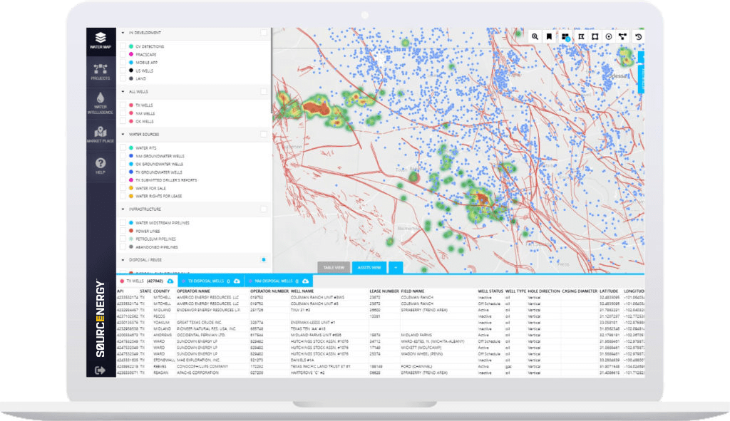
Sourcewater Geo™
The first geoscience platform custom-built for saltwater disposal design, optimization, and induced seismicity risk analytics.
Request demoSourcewater Geo is your best defense for protecting your assets and managing the risks caused by induced seismicity.
For over 100 years, geologists have studied the subsurface to find and extract hydrocarbons. Until very recently, the geoscience of saltwater production, injection and seismicity was an afterthought. Suddenly, disposal capacity forecasting and induced seismicity has become a core focus of upstream risk management and ESG performance.
The Sourcenergy geoscience team, led by the former Principal Investigator for the TexNet-CISR Injection and Production Analytics Project, has built the first data analytics platform devoted to the design, optimization and analysis of saltwater disposal: Sourcewater Geo™.
Sourcewater Geo™ includes all of the standard oil and gas, disposal and injection, groundwater and land data and GIS tools included in Sourcenergy GIS™, and all of the exclusive oilfield water data and infrastructure in Sourcewater Pro™. In addition, Sourcewater Geo™ includes proprietary geoscience data and models specific to saltwater disposal, injection and induced seismicity.
Sourcewater Geo™ Proprietary Geoscience Data & Models
- Daily Seismic Events (USA)
- Over 3,200 Permian geologic fault lines mapped with more than 1,800 in 3D with proprietary interpretations including formations of occurrence, strike, dip, length and type (TX, NM)
- True active intervals of injection for most disposal and injection wells (TX, NM)
- Stratigraphic maps of all 47 Permian disposal and injection formations (TX, NM)
- True formations of disposal, injection and production for most oil, gas, injection and disposal wells (TX, NM)
- Induced seismicity risk analytics for all existing SWDs (TX, NM)
- Cumulative injection and production volumes by true formation and area (TX, NM)
- Pressure utilization levels and trends by true formation of injection and area (TX, NM)
- Produced water flowcharts show seismic risks hidden in the supply chain
- Disposal Scorecard™ automated SWD application grading and documentation (TX)
- All data is exportable for use in other applications

Benefits
Geoscience & Supply Chain
Discover induced seismicity risk at your SWDs and hidden in your vendors’ SWDs without expensive 3D seismic surveys. Apply your own custom seismic risk criteria or use RRC criteria.
Geoscience
Identify potential catastrophic fault-fluid interactions for SWDs and hydraulic fractures.
Drilling & Operations
Avoid costly oil and gas well NPT or even blowouts from drilling through unexpected over-pressured disposal formations.
Geoscience
Forecast remaining pore space capacity for any SWD or formation by area.
Geoscience & Regulatory
Identify optimal tradeoffs between drilling cost, disposal capacity, permitting time and seismic risk for any proposed SWD in any location, then generate all the documentation needed for your permit application.
Facility Managers & OFS
Identify SWDs that are in need of and would respond best to service interventions.
ESG
Quantify and rank your induced seismicity risk compared to your peers.
| Sourcewater Geo™ includes all of the standard oil and gas, disposal and injection, groundwater and surface data and GIS tools, plus exclusive data sets below: | |
|---|---|
| Satellite Frac Ponds & Reserve Pits | Permian (TX, NM) |
| Produced Water Flow Charts between Producers & Disposers | TX, ND |
| Produced Water (Volumes, Source & Destination) | TX, ND |
| Private Water Midstream Pipelines: Over 9,000 Miles Mapped | USA |
| Daily Seismic Events | USA |
| Permian Geologic Fault Lines in 3D (Over 1,800 Mapped) | Permian (TX, NM) |
| True Active Intervals of Injection for All Disposal & Injection Wells | TX, NM |
| Stratigraphic Maps of All Disposal & Injection Formations | Permian (TX, NM) |
| True Formations of Disposal, Injection & Production | TX, NM |
| Induced Seismicity Risk Analytics | Permian (TX, NM) |
Request a free demo
Talk
Call us to learn how we can help you with your upstream energy and water intelligence needs