Casee Lemons, Director of Geoscience, Sourcewater, will be delivering an in-depth presentation on:
Managing Induced Seismicity
A System for Mapping the Geospatial Intersection of Saltwater Disposal Formations, Active Injection Intervals, Injection Pressures and Volumes, Geologic Fault Lines and Seismic Events in the Permian Basin
The presentation will be live and accessible on Monday July 26 at 11:40am at this year’s URTec 2021. Registration is required to attend. This event is both in-person and online.
Here is a detailed abstract of the presentation:
Managing Induced Seismicity: A System for Mapping the Geospatial Intersection of Saltwater Disposal Formations, Active Injection Intervals, Injection Pressures and Volumes, Geologic Fault Lines and Seismic Events in the Permian Basin
Abstract: URTec 2021, July 26-28, Houston, TX
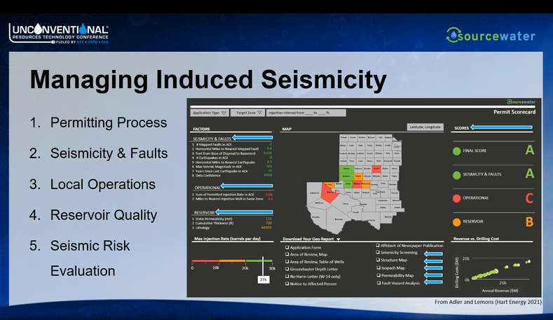
Background
Produced water management has become one of the biggest costs and risks of upstream energy production, revealing the void of complete, accurate models that map and characterize formations for saltwater disposal and their spatial relationship to geologic faults, which together may be associated with induced seismicity risks.
Also, water production type curves are more accurate when they include accurate formation details, and disposal wells can be more safely, reliably and cost-effectively permitted, constructed and operated with true saltwater formation depths and accurate active intervals in relation to geologic fault lines and seismic events in the vicinity.
Operators and disposal owners usually rely on permitted intervals and formations to make saltwater disposal well (SWD) design and planning decisions. But these permit data are inherently inaccurate, as permit filers always seek to maximize approved intervals for disposal that they rarely use in practice.
Operators often have detailed insights into the correct formations of injection, pressure levels and fault line proximities of their own SWDs, but they rarely have insight into the activities of their vendors’ and neighbors’ SWDs, which are just as important for assessing induced seismicity risks, causes and liabilities for the operator.
The industry needs better data on true formation depths and accurate active injection intervals across all disposal and injection wells to manage the safety, reliability and cost of saltwater disposal design, investment and operations.
Objectives
To solve this problem across the entire Permian Basin region, we built a data modeling system that identifies exactly which formations every SWD in the Permian Basin is injecting fluids into, further integrating current and historical injection volumes, pressures, geologic faults and seismic events. The system further integrates current Railroad Commission policies for triggering disposal permit seismic review, thereby alerting operators automatically as to whether a new or existing disposal permit may be delayed, denied or restricted. True stratigraphic horizons are used to estimate disposal plumes and subsurface pressure capacities. True producing formations can be used in calculating the impact of lateral length, adjacency, formation, and time on production and on parent-child relationships.
Procedures
Local land parcel ownership, wellbore architecture, permits, faults, and geologic formations were compiled and interpreted for geographic and geologic targets. Geologic formation occurrence was interpreted by intersecting wellbore architecture with gridded stratigraphic horizons and isopach maps.
Over 800,000 well-based formation records were used to create a 3D subsurface model of 42 formations and 1,537 faults in the Permian. Formation records were normalized to match custom stratigraphic columns designed for operators. Stratigraphy, structure, and geographic boundaries were reinforced and corrected by integrating regulatory databases and digitizing peer-reviewed maps. Faults were interpreted and added to a database featuring 13 different resources. Each fault was identified for its formation of occurrence, strike, dip, and age.
Wellbores were interpreted by intersecting the proposed and completed perforation intervals with gridded stratigraphic faulted horizons. We call these true formations because they are the zones completed, filling in the gap for wellbore records that only list permitted formations or have no data.
This process was applied to every active Underground Injection Control (UIC) well in Texas and New Mexico.
Monthly regulatory reports for every UIC well regarding volume and pressure of fluid injection were associated with each well, reaching back to the year 2000, further updating each month as new records become available.
All seismic events reported by TexNet and USGS are further integrated into the model back to the inception of those databases, updating daily. Drilling and completion activities are also tracked for the entire region, as some induced seismic events have been traced to hydraulic fracturing rather than saltwater disposal.
Results
Geologic summaries, formation properties, structural surface images, and boundary maps are featured with wellbore injection and production locations and histories and seismic events in a 3D geospatial visualization platform. Any well, set of wells, operator, geographic area or formation can be queried to generate analytics results for that subset.
RRC seismic review guidelines are automatically applied to all SWD locations and data to generate seismic review flags. Drilling and completion activities are also tracked for the entire region, as some induced seismic events have been traced to hydraulic fracturing rather than saltwater disposal.
Applications
There are several major applications for the system:
- Operators can assess their potential risk and liability for induced seismicity from third-party vendor SWDs where the operators sends its produced water for disposal. Such third party SWDs may be operated at different standard than the operator’s own wells or might be out of compliance with operator policies.
- Operators and other SWDs owners can assess potential risk for induced seismicity from all disposal and injection assets as well as hydraulic fracturing operations in a region, and identify possible third-party sources of seismic events, thereby mitigating claims against their own assets and operations.
- Companies planning new disposal wells can take into account the potential performance, time, cost and risk tradeoffs for any set of injection formations in any geography of interest, thereby making better well design and permitting decisions. For example, an operator might decide that a deep disposal well with high cost and high performance is a better choice than a shallow disposal with lower cost and lower performance. Or an operator might avoid building a new disposal in a location where a seismic review is likely to trigger a multi-year approval process and high permitting costs.
Post-conference, a copy of Ms. Lemon’s presentation will be available. Please contact us at [email protected] to request access to the presentation.