Great article on induced seismicity concerns in West Texas and New Mexico from Adrian Hedden in the Carlsbad Current-Argus.
Adrienne Sandoval, Division Director of Oil Conservation at New Mexico Energy, Minerals and Natural Resources, states that tracking produced water coming and going between NM and TX is “murky” due to a lack of tracking data.
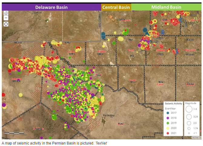
Culberson, Reeves and Scurry counties are leading this increase in seismic activity. As reports of earthquakes increase year over year in the Permian Basin the need for better analytics into produced water, where it is coming from and where it is going becomes more apparent.
Water pipeline infrastructure, water transfer data and increases in recycling systems are all part of managing produced water.
Knowing the depths, water volumes and subsurface formations are critical data necessary for any business planning a new disposal well, acquiring an existing well or filing a permit for a new SWD.
Sourcewater WaterMap GEO is a new geoscience platform built for induced seismicity risk analytics and SWD planning and placement.
Sourcewater has mapped out nearly 2,000 Permian geologic fault lines in 3-D so you can see where they intersect the true formations of injections for every existing or planned disposal well. Using this data will help you to optimize the performance and minimize the risks of new and existing wells or permits.
Additional features of WaterMap GEO include:
- Mapped flows of produced water from every producing well to every commercial disposal well in Texas and New Mexico
- Mapping of over 10,000 miles of water midstream pipelines, unavailable from any other source
- Geospatial data and metrics on fresh water and produced water – where it comes from and where it goes in the subsurface, by formation
Read the full article as reported by Adrian Hedden, Carlsbad Current-Argus: